slant2range
Syntax
Description
r = slant2range(sr,anht,tgtht)r, between a target and sensor as a
function of the target slant range sr, antenna height
anht, and target height tgtht, assuming a Curved Earth Model with an effective radius factor of
4/3. sr is the straight-line geometric distance between the target and
the sensor, whereas r is the distance along the slightly curved
propagated path that results from atmospheric refraction.
r = slant2range(sr,anht,tgtht,Name=Value)
[
also returns the elevation angle between the target and the propagated path
r,t_el,k] = slant2range(___)r, t_el, and the effective earth radius factor,
k.
If the outputs are returned as r = NaN,
t_el = NaN, and k =
1, the propagation path does not exist or cannot be computed for the
geometry specified by sr, anht, and
tgtht.
Examples
Calculate the propagated range from a slant range of 100 km, antenna height of 1 km, and target height of 2 km. Use default parameter values.
R = slant2range(100000,1000,2000)
R =
1.0001e+05
Compute the range between an antenna and a target. Start with a slant range of 250 km, an antenna height of 1 km, and target height of 5 km. Using the default 'Curved' Method, set an effective earth radius factor of 1.2.
Re = physconst('EarthRadius');
effactor = 1.2;
R = slant2range(250000,1000,5000,'EffectiveEarthRadius',effactor*Re)
R =
2.5002e+05
Calculate the propagated range and elevation angle of a target at a slant range of 300 km, an antenna height of 100 m, and target height of 5 km. Use the CRPL method and assume the surface refractivity is equal to 400 N-units. From the calculated propagated range and elevation angle, convert back to target height. Verify that the estimated target height from the range2height function matches the expected 5 km.
sr = 300000;
ha = 100;
ht = 5000;
Ns = 400;
rexp = refractionexp(Ns);
Calculate propagated range and elevation angle.
[R,el] = slant2range(sr,ha,ht,'Method','CRPL', ...
        'SurfaceRefractivity',Ns,'RefractionExponent',rexp)
R =
3.0009e+05
el =
0.1286
Convert propagated range and elevation angle back to target height. Verify that calculated value matches 5000 meters.
htest = range2height(R,ha,el,'Method','CRPL', ...,
    'SurfaceRefractivity',Ns,'RefractionExponent',rexp)
htest =
5.0000e+03
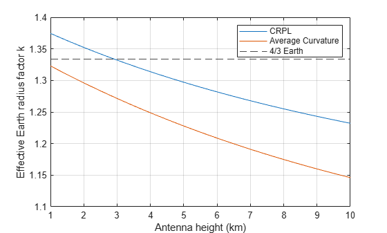
Compare the effective Earth radius factors calculated from the CRPL, the average radius of curvature, and 4/3 Earth models. Assume the slant range is 100000 m, the antenna heights range from 1 to 10 km, and the target is on the surface at zero altitude.
sr = 100000;
ha = linspace(1,10,50).*1000;
ht = 200;
[~,kAvgCurv] = effearthradius(sr,ha,ht);
[~,~,kCRPL] = slant2range(sr,ha,ht,'Method','CRPL');
Plot the effective earth radius factor as a function of antenna height.
plot(ha*1e-3,kCRPL)
hold on
plot(ha*1e-3,kAvgCurv)
yline(4/3,'--k')
grid on
legend('CRPL','Average Curvature','4/3 Earth')
ylabel('Effective Earth radius factor k')
xlabel('Antenna height (km)')
Input Arguments
Name-Value Arguments
Output Arguments
More About
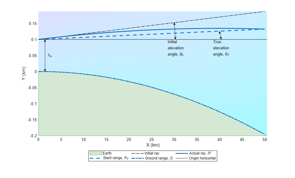
When the refractivity of air is incorporated into the curved Earth model, the ray paths do not follow a straight line but curve downward. (This statement assumes standard atmospheric propagation and nonnegative elevation angles.) The true elevation angle  is different from the initial
  . The actual range
  , which is the distance along the curved path
  , is different from the slant range
  .
.
Given the Earth's radius  , the antenna height
  , the initial elevation angle , and the height-dependent index of refraction
  with value
  at
at  , the modified model relates the target height
  and the actual range by
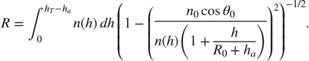
When Method is specified as "CRPL", the integral is solved using from CRPL Exponential Reference Atmosphere Model.
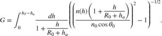
To compute the ground range  , use
, use
References
[1] Barton, David K. Radar Equations for Modern Radar. Norwood, MA: Artech House, 2013.
[2] Bean, B.R., and G.D. Thayer. "Central Radio Propagation Laboratory Exponential Reference Atmosphere." Journal of Research of the National Bureau of Standards, Section D: Radio Propagation 63D, no. 3 (November 1959): 315. https://doi.org/10.6028/jres.063D.031.
[3] Blake, Lamont V. "Ray Height Computation for a Continuous Nonlinear Atmospheric Refractive-Index Profile." Radio Science 3, no. 1 (January 1968): 85–92. https://doi.org/10.1002/rds19683185.
[4] Doerry, A. W. "Earth Curvature and Atmospheric Refraction Effects on Radar Signal Propagation." Sandia National Laboratories, SAND2012-10690 (Jan. 2013).
Extended Capabilities
Version History
Introduced in R2022b