maptrim
(Removed) Interactively trim vector data on axesm-based map
and convert to raster format
Syntax
maptrim(lat,lon,LineSpec)

maptrim(datagrid,refvec)

maptrim(datagrid,refvec,PropertyName,PropertyValue)
Description
maptrim(lat,lon) displays the supplied map data in a new figure
window and allows a region of the map to be selected and saved in the workspace.
lat and lon must be vector map data. The
output can be line, patch, or regular surface (matrix) data. If patch map output is
selected, the inputs lat and lon must originally
be patch map data.
maptrim(lat,lon,LineSpec) displays the supplied map using the
specified line style,
marker, and color.
maptrim(datagrid,refvec) displays data grid data in a new figure
window and allows a subset of this map to be selected and saved. The output is regular
surface data.
maptrim(datagrid,refvec,
displays the data grid using the surface properties provided. The object
PropertyName,PropertyValue)Tag, EdgeColor, and
UserData properties cannot be set.
Controls
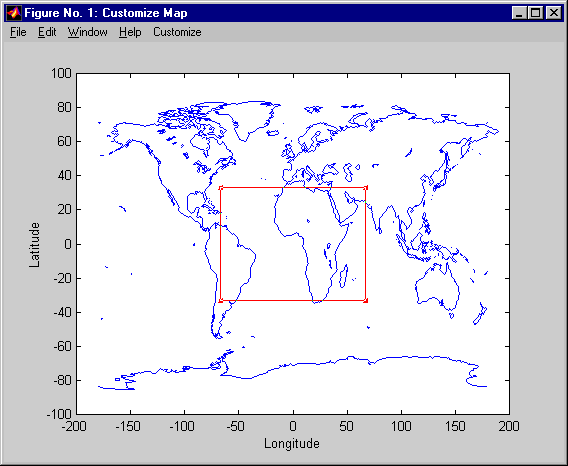
The maptrim tool displays the supplied map data in a new figure
window and activates a Customize menu for that figure.
The Customize menu has three menu options: Zoom On/Off, Limits, and
Save As.
The Zoom On/Off menu toggles interactive zoom on and off.
The Limits menu option activates the Enter Map Limits dialog box, which is used to enter the latitude and longitude limits of the desired map subset. These entries are two-element vectors, enclosed in brackets. Pressing the OK button zooms in to the new limits. Pressing the Cancel button disregards the new limits and returns to the map display.

The Save As menu option is used to specify the variable names in which to save the map data subset. To save line and patch data, enter the new latitude and longitude variable names, along with the map resolution. For surface data, enter the new map and referencing vector variable names, along with the scale of the map. Latitude and longitude limits are optional.
More About
Specify the line style, marker, and color as a character vector or string containing symbols.
The symbols can appear in any order. You do not need to specify all three characteristics
(line style, marker, and color). For example, specify a red dashed line using
'--r'.
| Line Style | Description | Resulting Line |
|---|---|---|
"-" | Solid line |
|
"--" | Dashed line |
|
":" | Dotted line |
|
"-." | Dash-dotted line |
|
| Marker | Description | Resulting Marker |
|---|---|---|
"o" | Circle |
|
"+" | Plus sign |
|
"*" | Asterisk |
|
"." | Point |
|
"x" | Cross |
|
"_" | Horizontal line |
|
"|" | Vertical line |
|
"square" | Square |
|
"diamond" | Diamond |
|
"^" | Upward-pointing triangle |
|
"v" | Downward-pointing triangle |
|
">" | Right-pointing triangle |
|
"<" | Left-pointing triangle |
|
"pentagram" | Pentagram |
|
"hexagram" | Hexagram |
|
| Color Name | Short Name | RGB Triplet | Appearance |
|---|---|---|---|
"red" | "r" | [1 0 0] |
|
"green" | "g" | [0 1 0] |
|
"blue" | "b" | [0 0 1] |
|
"cyan"
| "c" | [0 1 1] |
|
"magenta" | "m" | [1 0 1] |
|
"yellow" | "y" | [1 1 0] |
|
"black" | "k" | [0 0 0] |
|
"white" | "w" | [1 1 1] |
|