arcgridread
(Not recommended) Read gridded data set in ArcGrid ASCII or GridFloat format
arcgridread is not recommended. Use readgeoraster instead. For more information, see Version History.
Description
[
imports a grid in either ArcGrid ASCII or GridFloat format from the file specified
by Z,R] =
arcgridread(filename)filename. Returns Z, a 2-D array
containing the data values, and raster referencing information in
R. If the input file is accompanied by a projection file
(with extension .prj or .PRJ), then
R is a raster reference object whose type matches the
coordinate reference system defined in the projection file. Otherwise
R is a referencing matrix.
[
returns Z,R] =
arcgridread(filename,coordinateSystemType)R as a raster reference object whose type is consistent
with the value specified by coordinateSystemType. This optional
input argument can be helpful in the absence of a projection file. The function
throws an error if a projection file is present and
coordinateSystemType contradicts the type of coordinate
reference system defined in the projection file.
Examples
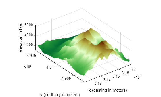
Read the data.
[Z,R] = arcgridread('MtWashington-ft.grd');Display the data as a surface. Add two labels to the display and set the colormap.
mapshow(Z,R,'DisplayType','surface')
xlabel('x (easting in meters)')
ylabel('y (northing in meters)')
demcmap(Z)

View the terrain in 3-D.
axis normal
view(3)
axis equal
grid on
zlabel('elevation in feet')
Input Arguments
Output Arguments
Tips
The
arcgridreadfunction does not import data in the ArcGrid Binary format (also known as ArcGrid, Arc/INFO Grid, and Esri ArcInfo Grid). ArcGIS uses this format internally and it uses multiple files in a folder with standard names such ashdr.adfandw001001.adf.