p618PropagationLosses
Calculate Earth-space propagation losses, cross-polarization discrimination, and sky noise temperature
Syntax
Description
[
returns Earth-space propagation losses pl,xpd,tsky] = p618PropagationLosses(p618cfg)pl, cross-polarization
discrimination xpd, and sky noise temperature
tsky, as defined in the ITU-R P.618-14 recommendation [1].
p618cfg specifies the P.618 configuration parameters.
This function requires a MAT file with digital maps from International Telecommunication Union (ITU) documents. If it is not available on the path, download and uncompress the data file from https://www.mathworks.com/supportfiles/spc/P618/ITURP618v14DigitalMaps.tar.gz to a location on the MATLAB® path.
Note
If you are using MATLAB in version R2025b or earlier, refer to the Tips section for instructions on how to run the examples by using ITU-R P.618-13.
Examples
This example requires a MAT file with digital maps from ITU documents. If the MAT file is not available on the path, execute the following commands to download and extract it.
matFile = exist('iturp618v14Maps.mat','file');
if ~matFile
    if ~exist('ITURP618v14DigitalMaps.tar.gz','file')
        url = 'https://www.mathworks.com/supportfiles/spc/P618/ITURP618v14DigitalMaps.tar.gz';
        websave('ITURP618v14DigitalMaps.tar.gz',url)
        untar('ITURP618v14DigitalMaps.tar.gz')
    else
        untar('ITURP618v14DigitalMaps.tar.gz')
    end
    addpath(cd)
end
Create a default P.618 configuration object.
cfg = p618Config;
Specify the time percentage of excess for the rain attenuation per annum as 0.01 and the time percentage of excess for the total attenuation per annum as 0.001.
cfg.RainAnnualExceedance = 0.01;
cfg.TotalAnnualExceedance = 0.001;
Calculate the propagation losses, cross-polarization discrimination, and sky noise temperature.
[pl,xpd,tsky] = p618PropagationLosses(cfg)
pl = struct with fields:
    Ag: 0.2278
    Ac: 0.2473
    Ar: 6.7981
    As: 0.2633
    At: 15.2643
xpd =
32.8876
tsky =
266.8455
This example requires a MAT file with digital maps from ITU documents. If the MAT file is not available on the path, execute the following commands to download and extract it.
matFile = exist('iturp618v14Maps.mat','file');
if ~matFile
    if ~exist('ITURP618v14DigitalMaps.tar.gz','file')
        url = 'https://www.mathworks.com/supportfiles/spc/P618/ITURP618v14DigitalMaps.tar.gz';
        websave('ITURP618v14DigitalMaps.tar.gz',url)
        untar('ITURP618v14DigitalMaps.tar.gz')
    else
        untar('ITURP618v14DigitalMaps.tar.gz')
    end
    addpath(cd)
end
Create a P.618 configuration object with a signal frequency of 20 GHz.
cfg = p618Config(Frequency=20e9);
Specify the surface water vapor density as 2.8, the total columnar content of the cloud liquid water as 1.4 , and the median value of the wet surface refractivity as 1.2. Set the earth station height as 0.5 km. Calculate the Earth-space propagation losses.
pl =  p618PropagationLosses(cfg,StationHeight=0.5, ...
                            WaterVaporDensity=2.8, ...
                            TotalColumnarContent=1.4, ...
                            WetSurfaceRefractivity=1.2)
pl = struct with fields:
    Ag: 0.8097
    Ac: 0.8986
    Ar: 0.8907
    As: 0.1372
    At: 2.4911
This example requires a MAT file with digital maps from ITU documents. If the MAT file is not available on the path, execute the following commands to download and extract it.
matFile = exist('iturp618v14Maps.mat','file');
if ~matFile
    if ~exist('ITURP618v14DigitalMaps.tar.gz','file')
        url = 'https://www.mathworks.com/supportfiles/spc/P618/ITURP618v14DigitalMaps.tar.gz';
        websave('ITURP618v14DigitalMaps.tar.gz',url);
        untar('ITURP618v14DigitalMaps.tar.gz');
    else
        untar('ITURP618v14DigitalMaps.tar.gz');
    end
    addpath(cd);
end
Create a P.618 configuration object that occupies a signal frequency of 20 GHz.
cfg = p618Config(Frequency=20e9);
Calculate the propagation losses in a light rainfall of 1 mm/hr with an earth station height of 0.75 km.
pl = p618PropagationLosses(cfg,RainRate=1,StationHeight=0.75)
pl = struct with fields:
    Ag: 0.7170
    Ac: 0.4763
    Ar: 0.0177
    As: 0.3187
    At: 1.0361
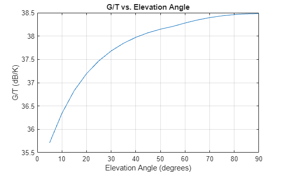
Use the ITU-R P.618 propagation loss model to calculate a satellite antenna gain-to-noise temperature ratio (G/T) value as a function of elevation angle. As the elevation angle increases, the noise temperature decreases because the received signal has traversed less atmosphere than at lower elevation angles.
This example requires a MAT file with digital maps from ITU documents. If the MAT file is not available on the path, execute the following commands to download and untar it.
matFile = exist('iturp618v14Maps.mat','file');
if ~matFile
    if ~exist('ITURP618v14DigitalMaps.tar.gz','file')
        url = 'https://www.mathworks.com/supportfiles/spc/P618/ITURP618v14DigitalMaps.tar.gz';
        websave('ITURP618v14DigitalMaps.tar.gz',url)
        untar('ITURP618v14DigitalMaps.tar.gz')
    else
        untar('ITURP618v14DigitalMaps.tar.gz')
    end
    addpath(cd)
end
Create a vector of elevation angles to analyze, and specify the attributes of a parabolic dish antenna.
elAngle = 5:5:90; % Elevation angle of antenna boresight pointing, in degrees

% Define circular aperture antenna properties. Assume a parabolic dish.
antDiam = 5.0;    % Antenna diameter, in meters
antEff = 0.6;     % Antenna efficiency, in range (0, 1]
freq = 28e9;      % RF frequency, in Hertz
tRcvr = 100;      % Noise temperature of receiving system, in Kelvin
Compute antenna gain at the frequency specified, in decibels relative to an isotropic antenna.
wavelen = physconst("LightSpeed")/freq;
antGain = 10*log10(antEff) + 20*log10((pi*antDiam)/wavelen);  % dBi
Calculate the sky noise temperature tsky at the geographical site over the vector of elevation angles. The location of the geographical site is 40.00 degrees North and -105.23 degrees West.
numElAngles = length(elAngle);
tSky = zeros(1,numElAngles);
for idxElevation = 1:numElAngles
  cfg = p618Config(Frequency=freq, ...                    % Hz
        ElevationAngle=elAngle(idxElevation), ...         % degrees
        Latitude=40.00, ...                               % degrees North
        Longitude=-105.23, ...                            % degrees West
        TotalAnnualExceedance=1.0, ...                    % percentage
        PolarizationTiltAngle=45, ...                     % degrees
        AntennaDiameter=antDiam, ...                      % meters
        AntennaEfficiency=antEff);                       % (0,1]
  [~,~,tSky(idxElevation)] = p618PropagationLosses(cfg);
end
Calculate the G/T value in decibels per Kelvin.
gT = antGain - 10*log10(tRcvr + tSky);  % G/T
plot(elAngle,gT)
title("G/T vs. Elevation Angle")
xlabel("Elevation Angle (degrees)")
ylabel("G/T (dB/K)")
grid on
Input Arguments
Name-Value Arguments
Output Arguments
Tips
For MATLAB version R2025b or earlier, the p618PropagationLosses object uses ITU-R
P.618-13 for its calculations instead of ITU-R P.618-14.
Use this code to download and unzip the MAT files containing digital maps from the ITU-R P.618-13 documents. The code also adds the extracted files to your MATLAB path.
maps = exist('maps.mat','file');
p836 = exist('p836.mat','file');
p837 = exist('p837.mat','file');
p840 = exist('p840.mat','file');
matFiles = [maps p836 p837 p840];
if ~all(matFiles)
    if ~exist('ITURDigitalMaps.tar.gz','file')
        url = 'https://www.mathworks.com/supportfiles/spc/P618/ITURDigitalMaps.tar.gz';
        websave('ITURDigitalMaps.tar.gz',url);
        untar('ITURDigitalMaps.tar.gz');
    else
        untar('ITURDigitalMaps.tar.gz');
    end
    addpath(cd);
endReferences
[1] International Telecommunication Union, ITU-R Recommendation P.618 (08/2023).
[2] International Telecommunication Union, ITU-R Recommendation P.676 (08/2022).
[3] International Telecommunication Union, ITU-R Recommendation P.1511 (08/2024).
[4] International Telecommunication Union, ITU-R Recommendation P.840 (08/2023).
[5] International Telecommunication Union, ITU-R Recommendation P.837 (06/2017).
[6] International Telecommunication Union, ITU-R Recommendation P.453 (08/2019).
[7] International Telecommunication Union, ITU-R Recommendation P.839 (09/2013).
[8] International Telecommunication Union, ITU-R Recommendation P.838 (03/2005).
[9] International Telecommunication Union, ITU-R Recommendation P.2145 (08/2022).