state
Inertial ground-truth state of actor
Syntax
Description
gTruth = state(ac)insSensor
System object™.
This function is supported only for actors that have trajectories created by using the
smoothTrajectory function.
Examples
Generate measurements from an INS sensor that is mounted to a vehicle in a driving scenario. Plot the INS measurements against the ground truth state of the vehicle and visualize the velocity and acceleration profile of the vehicle.
Create Driving Scenario
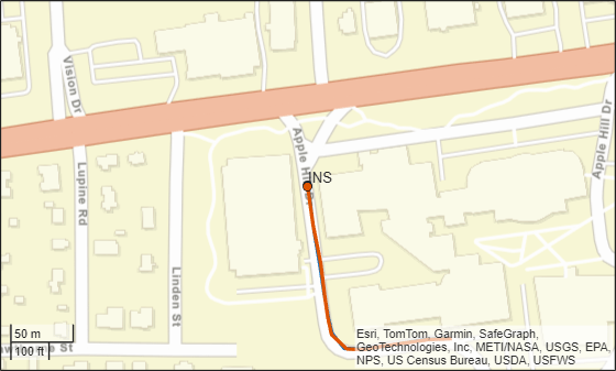
Load the geographic data for a driving route at the MathWorks® Apple Hill campus in Natick, MA.
data = load('ahroute.mat');
latIn = data.latitude;
lonIn = data.longitude;
Convert the latitude and longitude coordinates of the route to Cartesian coordinates. Set the origin to the first coordinate in the driving route. For simplicity, assume an altitude of 0 for the route.
alt = 0;
origin = [latIn(1),lonIn(1),alt];
[xEast,yNorth,zUp] = latlon2local(latIn,lonIn,alt,origin);
Create a driving scenario. Set the origin of the converted route as the geographic reference point.
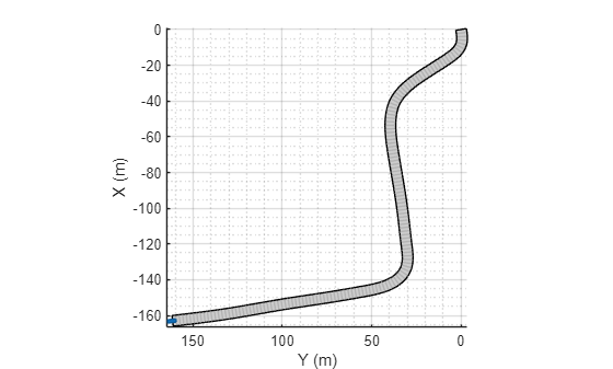
scenario = drivingScenario('GeoReference',origin);Create a road based on the Cartesian coordinates of the route.
roadCenters = [xEast,yNorth,zUp];
road(scenario,roadCenters);
Create a vehicle that follows the center line of the road. The vehicle travels between 4 and 5 meters per second (9 to 11 miles per hour), slowing down at the curves in the road. To create the trajectory, use the smoothTrajectory function. The computed trajectory minimizes jerk and avoids discontinuities in acceleration, which is a requirement for modeling INS sensors.
egoVehicle = vehicle(scenario,'ClassID',1);
egoPath = roadCenters;
egoSpeed = [5 5 5 4 4 4 5 4 4 4 4 5 5 5 5 5];
smoothTrajectory(egoVehicle,egoPath,egoSpeed);
Plot the scenario and show a 3-D view from behind the ego vehicle.
plot(scenario)
chasePlot(egoVehicle)
Create INS Sensor
Create an INS sensor that accepts the input of simulation times. Introduce noise into the sensor measurements by setting the standard deviation of velocity and accuracy measurements to 0.1 and 0.05, respectively.
INS = insSensor('TimeInput',true, ...
                'VelocityAccuracy',0.1, ...
                'AccelerationAccuracy',0.05);
Visualize INS Measurements
Initialize a geographic player for displaying the INS measurements and the actor ground truth. Configure the player to display its last 10 positions and set the zoom level to 17.
zoomLevel = 17;
player = geoplayer(latIn(1),lonIn(1),zoomLevel, ...
    'HistoryDepth',10,'HistoryStyle','line');
Pre-allocate space for the simulation times, velocity measurements, and acceleration measurements that are captured during simulation.
numWaypoints = length(latIn);
times = zeros(numWaypoints,1);
gTruthVelocities = zeros(numWaypoints,1);
gTruthAccelerations = zeros(numWaypoints,1);
sensorVelocities = zeros(numWaypoints,1);
sensorAccelerations = zeros(numWaypoints,1);
Simulate the scenario. During the simulation loop, obtain the ground truth state of the ego vehicle and an INS measurement of that state. Convert these readings to geographic coordinates, and at each waypoint, visualize the ground truth and INS readings on the geographic player. Also capture the velocity and acceleration data for plotting the velocity and acceleration profiles.
nextWaypoint = 2;
while advance(scenario)

    % Obtain ground truth state of ego vehicle.
    gTruth = state(egoVehicle);

    % Obtain INS sensor measurement.
    measurement = INS(gTruth,scenario.SimulationTime);

    % Convert readings to geographic coordinates.
    [latOut,lonOut] = local2latlon(measurement.Position(1), ...
                                   measurement.Position(2), ...
                                   measurement.Position(3),origin);

    % Plot differences between ground truth locations and locations reported by sensor.
    reachedWaypoint = sum(abs(roadCenters(nextWaypoint,:) - gTruth.Position)) < 1;
    if reachedWaypoint
        plotPosition(player,latIn(nextWaypoint),lonIn(nextWaypoint),'TrackID',1)
        plotPosition(player,latOut,lonOut,'TrackID',2,'Label','INS')

        % Capture simulation times, velocities, and accelerations.
        times(nextWaypoint,1) = scenario.SimulationTime;
        gTruthVelocities(nextWaypoint,1) = gTruth.Velocity(2);
        gTruthAccelerations(nextWaypoint,1) = gTruth.Acceleration(2);
        sensorVelocities(nextWaypoint,1) = measurement.Velocity(2);
        sensorAccelerations(nextWaypoint,1) = measurement.Acceleration(2);

        nextWaypoint = nextWaypoint + 1;
    end

    if nextWaypoint > numWaypoints
        break
    end

end
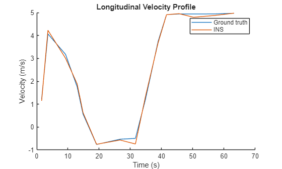
Plot Velocity Profile
Compare the ground truth longitudinal velocity of the vehicle over time against the velocity measurements captured by the INS sensor.
Remove zeros from the time vector and velocity vectors.
times(times == 0) = [];
gTruthVelocities(gTruthVelocities == 0) = [];
sensorVelocities(sensorVelocities == 0) = [];

figure
hold on
plot(times,gTruthVelocities)
plot(times,sensorVelocities)
title('Longitudinal Velocity Profile')
xlabel('Time (s)')
ylabel('Velocity (m/s)')
legend('Ground truth','INS')
hold off
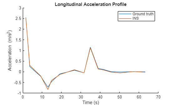
Plot Acceleration Profile
Compare the ground truth longitudinal acceleration of the vehicle over time against the acceleration measurements captured by the INS sensor.
gTruthAccelerations(gTruthAccelerations == 0) = [];
sensorAccelerations(sensorAccelerations == 0) = [];

figure
hold on
plot(times,gTruthAccelerations)
plot(times,sensorAccelerations)
title('Longitudinal Acceleration Profile')
xlabel('Time (s)')
ylabel('Acceleration (m/s^2)')
legend('Ground truth','INS')
hold off
Input Arguments
Output Arguments
Version History
Introduced in R2021a
See Also
insSensor | drivingScenario | actor | vehicle | smoothTrajectory